Desktop application
NMEA Simulator X is the Qt Widgets host of the simulation engine. It runs the same
SimulationRunner as the command-line tool and reads and writes the same
profile files.
Command line
NMEASimulatorX [profile.json]
When a profile path is given it is loaded at start-up. A profile that cannot be opened, for example because the path does not exist or its track file is missing, is reported in a message box, and the last profile used is reopened instead. Without a path the last profile used is reopened, and if there is none the built-in default profile is used.
Window layout
| Area | Contents | Can be hidden |
|---|---|---|
| Dashboard (central) | Compass rose and wind dial, then instrument tiles with override controls; scrolls when the window is small | No |
| Map (dock, left) | Vessel, heading, course line and track on a slippy map | Yes, View menu |
| Console (dock, bottom) | Sentences as sent, with pause, filter and clear | Yes, View menu |
| Outputs (dock, right) | One row per configured output: description, state, clients, lines sent (sentences, or Signal K or ViewSync messages), bytes, last error | Yes, View menu |
| Status bar | Indicator lights for the run state (green RUNNING, amber PAUSED, unlit STOPPED) and recording (a blinking red REC), then the profile name and mode; on the right the outputs light (n/m OUTPUTS: green when all are open, amber while some are opening, red when one failed) and the counter of NMEA 0183 sentences produced. Errors appear here for ten seconds | No |
Docks can be moved to any edge, stacked, floated or closed. Geometry and dock layout are saved on exit and restored at the next start; the first start gives the map about 400 pixels, the outputs about 260 and the console about 170.
Actions and shortcuts
| Menu | Action | Shortcut | Effect |
|---|---|---|---|
| File | New profile | Ctrl+N | Replaces the current profile with the default one |
| File | Open profile... | Ctrl+O | Loads a JSON profile; the simulation restarts if it was running |
| File | Save profile | Ctrl+S | Writes the current profile to its file, asking for a name the first time |
| File | Save profile as... | Ctrl+Shift+S | Writes the current profile to a new file, which becomes the profile's file once written |
| File | Open track... | Ctrl+T | Switches the current profile to track mode with a GPX or KML file; the simulation restarts if it was running |
| File | Open log for replay... | Ctrl+L | Switches the current profile to replay mode with a recorded or plain NMEA log |
| File | Record log... | Ctrl+R | Starts recording every sentence to a log file, or stops the recording when unticked |
| File | Settings... | Ctrl+, | Opens the settings dialog for the current profile |
| File | Quit | Ctrl+Q | Stops the simulation and closes the window |
| Simulation | Start / Stop | F5 | Opens every enabled output and starts ticking, or closes everything |
| Simulation | Pause | F6 | Freezes the simulated clock and the vessel; outputs stay open |
| Simulation | Step | F7 | Pauses and advances by one tick, or by one recorded sentence during a replay; starts the run paused when it is stopped |
| Simulation | Steering mode | Arrow keys move the rudder instead of the heading; available in delta mode only, and unticked when a track or log is loaded | |
| Simulation | Clear destination | Stops steering for the waypoint; APB, RMB and XTE are no longer sent | |
| Simulation | Start automatically on launch | Starts the simulation as soon as the window opens | |
| View | Map, Console, Outputs | Shows or hides the panel | |
| View | Follow vessel on the map | Home | Keeps the map centred on the vessel; dragging the map switches it off |
| View | Download map tiles | Fetches missing tiles from the tile server; off uses the disk cache only | |
| View | Clear map tile cache | Deletes every cached tile from disk and memory | |
| View | Theme | Follow the system, Night bridge (dark) (the default) or Daylight (light); see Appearance | |
| Help | About | Version and project link; development builds add the git describe string of their commit, as nmeasim --version does |
On macOS the Ctrl shortcuts use Cmd.
Transport controls
The toolbar ends with a seek slider and a position label. Both are active while the profile follows a track or replays a log, whose length is known, and disabled for the delta simulation, which is endless.
| Control | Effect |
|---|---|
| Pause | Stops the clock; the outputs stay open |
| Step | One tick of the simulation (the profile's simulation step), or exactly the next recorded sentence during a replay |
| Slider | Drag or click to move to that point of the track or log. The vessel state and the map change at once; during a replay the sentences before the new position are applied to the state without being sent |
| Label | Elapsed and total time as mm:ss or h:mm:ss |
A track or log that is not set to loop ends the run by itself: the last sentence is sent, the status bar reports End of the track or log reached and the outputs close.
Modes
The profile decides what drives the vessel:
| Mode | Vessel | Dashboard | Map |
|---|---|---|---|
| Delta simulation | Seed values that drift, with overrides and steering | Overrides active | Vessel and sailed track |
| Follow a track | A GPX or KML file | Overrides disabled | The loaded track is drawn in green under the sailed track |
| Replay a log | The sentences of a log file, decoded into the state | Overrides disabled | Vessel and sailed track from the decoded positions |
Use File → Open track... or Open log for replay... to switch the current profile to those modes with one file, or the Mode group of the settings dialog to set every option. File → New profile or the settings dialog return to the delta simulation.
Recording
File → Record log... asks for a file and records every emitted sentence, whatever the profile outputs and their filters, in the log format. The file is truncated when the recording starts and continued across Stop and Start until the action is unticked. The status bar and the action's tooltip show the file being written. To record only some sentences, add a Log output with a filter in the settings dialog instead.
Keyboard control of the vessel
The main window must have focus; click on the dashboard if the arrow keys do not respond.
| Key | Parameter | Step | With Shift |
|---|---|---|---|
| Up / Down | Speed over ground | 0.1 kn | 1 kn |
| Left / Right | Heading (steering mode off) | 1° | 10° |
| Left / Right | Rudder angle (steering mode on) | 1° | 10° |
A nudge sets an override on the parameter, which pins it at the new value until the override is cleared from the tile. In track and replay mode the file drives the vessel, so the arrow keys nudge nothing and are left to the rest of the window.
Dashboard instruments
The top row holds two round instruments and the position, time and GNSS tiles:
| Instrument | Shows |
|---|---|
| Compass | North-up rose with 5° ticks. The heading is the cyan pointer, the course over ground a green triangle on the ring and, with a destination, the bearing to it a magenta diamond. The centre reads HDG, and below it COG and BRG |
| Wind | Angles relative to the bow, with the close-hauled sectors (20° to 60°) red to port and green to starboard. The apparent wind is the cyan arrow, the true wind the hollow triangle. The centre reads the apparent wind speed (AWS), the apparent wind angle (AWA), the true wind angle (TWA) and speed (TWS); angles are written as sailors say them, 104°P to port, 30°S to starboard |
Dashboard tiles
| Tile | Shows | Override |
|---|---|---|
| Position | Latitude and longitude in degrees and decimal minutes, on two lines | No |
| Time (UTC) | Simulated clock | No |
| GNSS | Fix state, satellites in use, HDOP | Fix check box, Satellites spin box (0 to 12) |
| Heading | True heading | Yes, 0 to 359.9°; disabled in steering mode |
| Course over ground | Derived from heading and drift | No |
| Rate of turn | Degrees per minute | No |
| Speed over ground | kn | Yes |
| Speed through water | kn | Yes |
| Rudder | Rudder angle | Yes, within the profile's maximum rudder angle (±35° by default); enabled only in steering mode |
| Depth | Below transducer, m | Yes |
| Water temperature | °C | Yes |
| Altitude | m | Yes |
| True wind direction | Degrees true | Yes |
| True wind speed | kn | Yes |
| Apparent wind | Angle and speed derived from true wind and vessel motion; the angle is written as on the wind dial, 104°P to port, 30°S to starboard |
No |
| Destination | Waypoint id, bearing and distance to it, cross-track error and the side to steer; None without a destination | No, set it on the map |
| Engines | One tile per configured engine with its label, a Running switch, revolutions and coolant temperature | Yes, every field; changes apply at once to RPM, XDR, the AIS and Signal K output |
An active override stops the random drift of that parameter, and the tile gets an amber border so that overridden values stand out. Clearing it lets the value drift again from where it is: a value pinned outside the seed plus or minus the amplitude drifts back towards that band at its normal step rate, one full step per tick, and then wanders within it. In steering mode the heading follows the rudder even when its override is set; switching steering off leaves the override holding the heading where the rudder left it. In track and replay mode every override control is disabled, because the file drives the vessel.
Map
The map shows the vessel as a yellow hull pointing along its true heading, with a thin heading line ahead of the bow and a dashed course vector along the course over ground that ends, with a small circle, where the vessel will be in six minutes at its speed over ground. The positions sailed since the profile was applied form a red track (at most 5000 points). In track mode the loaded track or route is drawn in green underneath, with a marker on every point when it has 500 points or fewer.
Overlays keep the chart readable:
| Where | Overlay |
|---|---|
| Top left | Zoom level (with one decimal between whole levels) and offline, free view or destination set; below it a north arrow, as the chart is always north up |
| Top right | Buttons + and − (zoom one level) and Follow the vessel (lit while following) |
| Bottom left | Scale bar in round nautical miles (0.1 to 5000 nm), or metres below 0.1 nm |
| Bottom right | The position under the pointer while it is over the map, and the attribution of the tile server |
The zoom level is continuous: the wheel, the touchpad and pinch gestures zoom smoothly, using the tiles of the nearest whole level scaled to fit, while the keys and buttons step to whole levels. The map pans freely across the 180th meridian: the world repeats east and west, and positions picked on the map always have a longitude between -180° and 180°.
| Input | Effect |
|---|---|
| Drag with the left button | Pans the map and switches Follow vessel off |
| Mouse wheel or two-finger touchpad scroll | Zooms smoothly around the pointer, or around the vessel while Follow vessel is on; one wheel notch is one level |
| Pinch on a touchpad | Zooms smoothly around the fingers, where the platform reports pinch gestures (macOS, Wayland) |
| + / − buttons | Zoom in or out one level around the centre |
| + / - | Zooms in or out around the centre |
| Home, or the Follow the vessel button | Switches Follow vessel on and recentres |
| Double-click, or Ctrl and click | Moves the vessel to that point |
| Shift and click | Sets the destination waypoint at that point; the leg starts where the vessel is |
| Right click | Menu with Move vessel here, Set destination here and Clear destination |
Moving the vessel changes the running simulation immediately and also the start position of
the current profile, so saving the profile keeps the new place. The sailed track starts a new
segment at the new place instead of drawing a line from the old one, and a destination's leg
restarts there as well. Seeking in a track or log also starts a new segment. The destination is drawn as a
magenta diamond with a dashed bearing line from the vessel and a dotted line for the leg from
its origin; the words destination set appear in the corner. Setting or clearing it changes
the running simulation and the profile seed at once; the waypoint id is WPT until it is
renamed on the Simulation tab of the settings dialog. See
Set a destination.
Tiles
Tiles follow the slippy map scheme and come from a tile server given as a URL template
with {z}, {x} and {y} placeholders. The default is the OpenStreetMap server,
https://tile.openstreetmap.org/{z}/{x}/{y}.png, used under its
tile usage policy: requests carry
a User-Agent naming this application and its version, at most four downloads run at a time,
every tile is cached and a tile that failed is not requested over and over. Set another server
through the map/tile_url preference.
A tile the server does not have (HTTP 404 or 410) is not requested again until the application restarts. After any other failure, such as no network connection, a timeout or another HTTP error, the tile is requested again at the earliest 30 seconds later, and each further failure of the same tile doubles that delay up to 10 minutes. Unticking and ticking View → Download map tiles again retries those tiles at once.
The map credits © OpenStreetMap contributors in its bottom-right corner when the tiles come
from an OpenStreetMap server (a host ending in openstreetmap.org). For any other server it
draws no attribution, because it cannot know that server's terms: put the credit the server
asks for in the map/tile_attribution preference, which replaces the default for every
server (an empty value draws none).
Every downloaded tile is written to the tile cache directory below, so once an area has been viewed it stays available without a network connection. When a tile is missing the map shows the matching part of the nearest cached lower zoom level, or a grey square when there is none. Untick View → Download map tiles to stop all network access; the map then uses the cache only and shows offline. Unticking it also cancels the downloads in progress, as does View → Clear map tile cache.
| Platform | Tile cache directory |
|---|---|
| Windows | %LOCALAPPDATA%\NMEASimulatorX\NMEASimulatorX\cache\tiles |
| macOS | ~/Library/Caches/NMEASimulatorX/NMEASimulatorX/tiles |
| Linux | ~/.cache/NMEASimulatorX/NMEASimulatorX/tiles |
The map/cache_directory preference moves the cache: the tiles are then kept in its tiles
sub-directory, which Clear map tile cache deletes, and the change takes effect at the next
start.
Console
The console buffers sentences and repaints a few times per second so that high output rates
do not slow the interface. It keeps the last 2000 lines. The filter matches the registry id
(for example RMC) or any part of the sentence text (for example $HC), case-insensitively,
and applies to new sentences only. Pause stops new sentences from being added without
affecting the simulation.
Lines are coloured like a protocol analyser: the talker ($GP, !AI), the sentence
formatter (RMC, in bold), the field separators, the checksum and an IEC 61162-450 TAG block
each have their own colour, and Signal K and other JSON messages are shown in one colour.
Outputs
The table refreshes twice a second and whenever an output changes state. The state column uses the names listed in the transport reference, with a coloured light: green open, amber opening, red failed, grey closed. An output that fails to open is reported in the status bar and in the Last error column while the run continues on the other outputs.
Appearance
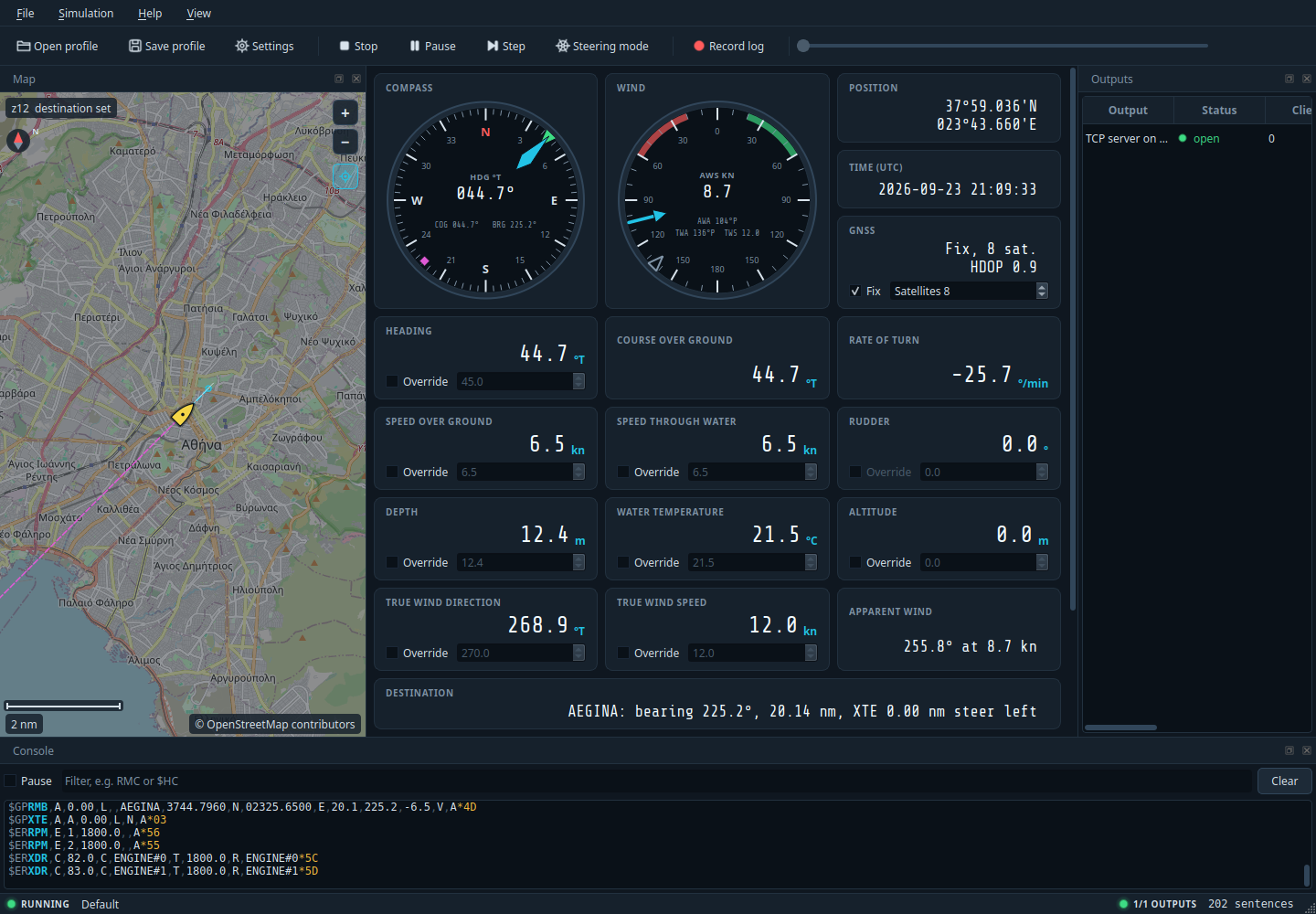
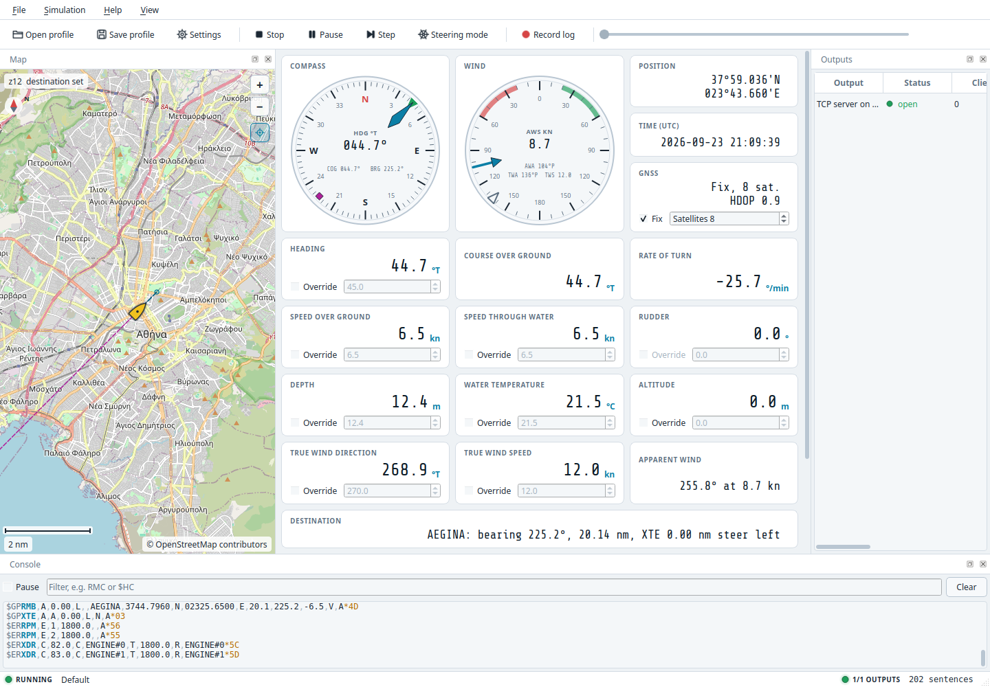
View → Theme switches between two looks at once, and the choice is kept:
| Theme | Look |
|---|---|
| Night bridge (dark), the default | Charcoal and navy panels with cyan accents, as on a ship's bridge at night; map tiles are darkened so that they do not dazzle |
| Daylight (light) | White and light grey panels with teal accents and normal map colours, for bright rooms |
| Follow the system | Night or daylight after the desktop's dark or light setting, switching when the desktop does |
Instrument readouts use the Share Tech Mono typeface by Carrois Type Design, bundled with the
application under the SIL Open Font License 1.1 (installed as ShareTechMono-OFL.txt next to
the licence of the application). Toolbar icons are drawn by the application and follow the
theme.
Settings dialog
File → Settings... edits a copy of the current profile in four tabs. OK applies the result as the current profile, restarting the simulation if it was running; Cancel discards every change. The profile on disk is not touched until you save it.
Simulation tab
| Group | Fields |
|---|---|
| Mode | Vessel driven by: delta simulation, follow a track or replay a log |
| Track | File (with Browse...), speed without timestamps, follow the track's own timestamps, start again at the end; enabled in track mode |
| Log replay | File (with Browse...), interval without times, start again at the end; enabled in replay mode |
| Profile and clock | Name, simulation step (10 to 10000 ms), fixed start time in UTC or the wall clock, random seed (0 to 4294967295) |
| Initial vessel values | Latitude, longitude, altitude, heading, speed over ground, magnetic variation and deviation, depth, transducer offset, water temperature, true wind direction and speed |
| GNSS receiver | Fix, fix quality, satellites in use and in view, HDOP, PDOP, VDOP, geoid separation |
| Drift around the initial values | Amplitude and step per second for heading, speed, depth, water temperature, wind direction and wind speed; an amplitude of 0 freezes the value; enabled in delta mode |
| Destination | Steer for a waypoint, its id, latitude, longitude and arrival circle radius; a new destination starts its leg at the initial position, and one whose coordinates were not edited keeps its leg |
| Steering | Turn rate per degree of rudder, maximum rudder angle |
The fields map one to one onto the simulation object of the
profile file. Latitudes and longitudes are shown with six decimals;
a coordinate whose field is left unchanged keeps all the decimals it has in the profile.
Vessel tab
| Group | Fields |
|---|---|
| Engines | A table with one row per engine: label, running, revolutions, coolant temperature; Add engine and Remove. The first row is engine 1 in RPM and ENGINE#0 in XDR; the Signal K id comes from the label. |
| AIS static data | MMSI, IMO number, vessel name, call sign, ship type code, antenna distances to bow, stern, port and starboard, draught, voyage destination, navigational status, position report type; see the AIS reference |
Sentences tab
One row per sentence in the registry with its enabled flag, id, description, group, talker and period in milliseconds. A talker is two letters; an empty talker uses the registry default shown as placeholder, and OK refuses a single letter. Enable all, Disable all and Reset to defaults act on every row, and leave Position decimals alone, which sets the fractional minute digits of latitude and longitude.
Only rows that differ from the registry defaults are written to the profile, so a saved profile stays small and follows registry changes in later versions.
Below the registry, the Custom sentences table holds the operator's own sentences
(reference): an enabled flag, an id (empty gives
CUSTOM-n, where n is the row number shown as placeholder), the sentence without checksum
and its period. OK refuses a body that cannot be framed, an id that belongs to a registry
sentence and an id used by two rows, naming the rows.
Outputs tab
The list on the left holds the outputs in the order they are opened. Add offers every transport type, including Log (timestamped) for a filtered recording; Remove deletes the selected output. The editor on the right shows the common fields, Enabled, the comma-separated Sentence filter, the Encoding and the Period, above the fields of the selected type as listed in the transport reference. Serial ports found on the machine are offered in the port list, and any other device path can be typed.
The encoding decides what the output carries and which option group appears below the type fields (profile reference):
| Encoding | Filter | Option group |
|---|---|---|
| NMEA 0183 sentences | Registry and custom sentence ids | IEC 61162-450 TAG block: enable, source, include the time, time in milliseconds |
| Signal K deltas | Path prefixes such as navigation |
Signal K: context (vessel with the AIS MMSI, aircraft, or a custom string) and source label; Period sets the delta rate |
| ViewSync packets | not used | ViewSync camera: height above the vessel, tilt, roll, planet; Period sets the packet rate |
OK is refused, with the reason shown under the tabs, while the track or replay mode has no file, a serial output has no port or baud rate, a file or log output has no path or a TCP client has no host, a registry sentence has a one-letter talker, or two custom sentences share an id.
Preferences
Application preferences are separate from profiles and are stored with QSettings in the
platform's native location:
| Platform | Location |
|---|---|
| Windows | Registry key HKEY_CURRENT_USER\Software\NMEASimulatorX\NMEASimulatorX |
| macOS | ~/Library/Preferences/io.github.dimitrios-kafetzis.NMEASimulatorX.plist |
| Linux | ~/.config/NMEASimulatorX/NMEASimulatorX.conf |
| Key | Meaning |
|---|---|
profile/last_path |
Profile reopened at the next start |
window/geometry, window/state |
Window size, position and dock layout |
simulation/autostart |
Whether the simulation starts on launch |
map/online |
Whether missing tiles are downloaded (default true) |
map/tile_url |
Tile URL template; empty uses the OpenStreetMap server |
map/tile_attribution |
Attribution drawn on the map; unset credits OpenStreetMap for its own servers only |
map/zoom |
Last map zoom level, fractional |
map/cache_directory |
Directory whose tiles sub-directory holds the tile cache; empty uses the platform's cache directory above |
appearance/theme |
night (default), day or system |
The default folder offered by the profile dialogs is the profiles sub-folder of the
application's configuration directory.